
Tropical Cyclone Advisory No. 1: The Latest Developments of Tropical Cyclone Outside PAR
CURRENT EVENT
LTM, Dreamer
11/3/20242 min read
Tropical Depression Develops Outside Philippine Area
As of 5:00 PM on November 3, 2024, the tropical cyclone advisory No. 1 has been officially released, acknowledging the development of a low-pressure area outside the Philippine Area of Responsibility (PAR) into a tropical depression. This meteorological event signifies the potential onset of severe weather conditions and warrants attention from residents and authorities alike.
(Note to our readers: In behalf of the team, we humbly apologize for the typographical errors that had been published an hour ago. We will clarify to you hat Typhoon Lane is the other typhoon, here is some updates https://www.cyclocane.com/lane-storm-tracker/ of it. Thank you so much!)
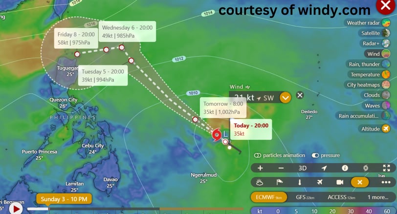
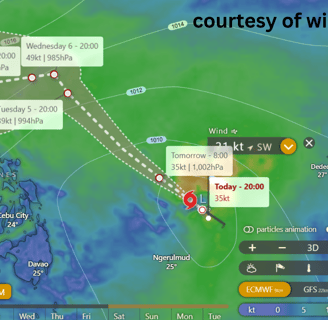
This tropical depression has the international name of "YINXING" and it will have the name MARCE when it enters the Philippine Area of Responsibility most probably tomorrow November 4, 2024 and now became Tropical Storm. (Official statement from DOST_PAGASA as of 2:00 a.m.)
Current Status and Movement of the Tropical Depression
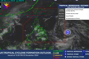
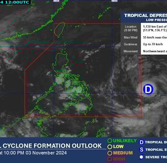
The center of the tropical depression has been calculated to be approximately 1,315 kilometers east of Eastern Visayas, which translates to coordinates of 9.8°N and 137.7°E. It boasts maximum sustained winds of 55 km/h in close proximity to its center, with gustiness reaching up to 70 km/h. The central pressure of this weather system has been measured at 1004 hPa. Such intensity indicates that this tropical depression could escalate if conditions permit, making it essential for communities in potential impact zones to remain vigilant.
Forecast and Precautions Moving Forward
Although the current trajectory shows the tropical depression progressing northwestward at a pace of 30 km/h, the extent of its winds expands outwards up to 340 km from the center. This means that strong winds can affect areas significantly distanced from the depression’s eye, increasing the likelihood of adverse weather, including rain, storm surges, and heavy winds in the following hours. Advisory warnings remain valid for broadcast until the next bulletin is issued at 11:00 PM today.
It is crucial to stay updated with local weather reports and heed guidelines from authorities regarding necessary precautions. Community preparedness, timely evacuation if required, and ensuring that emergency supplies are readily accessible can significantly mitigate risk posed by this tropical cyclone.
As we observe the ongoing developments of this tropical depression, awareness and preparedness remain vital. Stay tuned for further information and updates from meteorological services, and remain safe as we monitor this evolving situation.
latest updates from DOST_PAGASA
As of 11 p.m. NOVEMBER 2, 2024
https://www.facebook.com/photo/?fbid=985688886936098&set=a.365711365600523
aS OF 2 A.M NOVEMBER 4, 2024
Insights
Honest reviews for informed shopping decisions.
Quality
Trust
info@reviewph.com
+63-9197557861
Disclaimer: The material used in this is purely for [educational/entertainment/informational/etc.] purposes. We do not claim ownership of the [music/images/footage/etc.] used, and no copyright infringement is intended. All rights go to their respective owners. If you are the [artist/creator/rights holder/etc.] and would like us to remove this content, please contact us and we will comply with your request immediately.
© 2024. All rights reserved.