
Tropical Cyclone and Low Pressure Area Update: Monitoring Severe Storms and Developing Systems
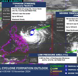
Tropical Cyclone and Low Pressure Area Update (as of 4:00 AM): Severe Tropical Storm NIKA, with international named TORAJI, continues to move over Philippine waters. Currently classified as a severe tropical storm, NIKA is expected to bring heavy rainfall, strong winds, and potential flooding to affected regions. Coastal and mountainous areas should prepare for intense rain, with the potential for rough seas near affected coastlines. Typhoon YINXING (formerly MARCE) (#MarcePH) Typhoon YINXING, previously known in the Philippines as MARCE, has strengthened as it moves further. Currently at typhoon intensity, YINXING is outside the Philippine Area of Responsibility but may still influence weather patterns in the region. The typhoon is anticipated to bring additional winds and rainfall, particularly along the northern parts of Luzon.
CURRENT EVENT
LTM, Dreamer
11/9/20242 min read
Philippines Current Weather Systems
As of 4:00 AM today, severe tropical storm 'Nika' (Toraji) #NikaPH and typhoon (Yinxing) (formerly 'Marce') #MarcePH are creating considerable weather concerns across various regions. With emerging systems in play, it is crucial for the public to remain informed and vigilant. DOST-PAGASA recommends close monitoring of weather updates as these systems evolve.
Severe Tropical Storm 'Nika' and Typhoon 'Marce'
Severe tropical storm 'Nika', known by its local name Toraji, is currently exhibiting intensifying characteristics. This storm poses threats due to heavy rainfall and strong winds, potentially leading to hazardous conditions in affected areas. Meanwhile, typhoon 'Marce', now designated as Yinxing, is also under close scrutiny due to its previous formation stages. Both storms bring with them risks of flooding and landslides, making it imperative for residents in their projected paths to prepare accordingly.
Developing Low Pressure Area
In addition to the storms already mentioned, a low pressure area (LPA 11C) exists that has a high likelihood of developing into a tropical depression within the next 24 hours. While still in its early stages, this system should not be underestimated. Meteorological patterns suggest that as this weather system continues to develop, it may strengthen and potentially impact surrounding regions. Stakeholders, including local governments and emergency services, are encouraged to activate disaster response protocols as needed, based on evolving forecasts.
Recommendations for Safety and Monitoring
The public is strongly advised to stay updated on the latest developments from DOST-PAGASA, which regularly provides crucial updates on these severe weather systems. Preparedness is key in mitigating risks associated with tropical cyclones, especially regarding flooding and storm surges. Residents in high-risk areas should ensure emergency kits are ready, stay indoors during severe conditions, and heed any evacuation orders that may be issued.
Conclusion
In conclusion, both severe tropical storm 'Nika' and typhoon 'Marce' require our utmost attention. Additionally, the developing LPA 11C poses further weather threats that must not be ignored. By staying informed through reliable sources such as DOST-PAGASA, individuals can take proactive measures to ensure their safety and that of their loved ones. Weather systems can shift rapidly, so continuous monitoring is crucial in navigating through these unpredictable scenarios.
FURTHER INFORMATION
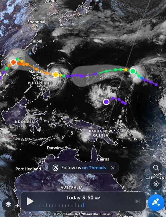
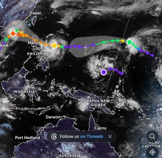
Photo from zoomearth.com
Photo from DOST PAGASA https://www.facebook.com/photo/?fbid=990467663124887&set=a.365711365600523

Press Briefing: Severe Tropical Storm #NikaPH {Toraji} at 5 AM | November 10, 2024 - Sunday
GOST_PAGASA
Insights
Honest reviews for informed shopping decisions.
Quality
Trust
info@reviewph.com
+63-9197557861
Disclaimer: The material used in this is purely for [educational/entertainment/informational/etc.] purposes. We do not claim ownership of the [music/images/footage/etc.] used, and no copyright infringement is intended. All rights go to their respective owners. If you are the [artist/creator/rights holder/etc.] and would like us to remove this content, please contact us and we will comply with your request immediately.
© 2024. All rights reserved.