
Tropical Cyclone Update No. 4 – Severe Tropical Storm Marce (Yinxing)
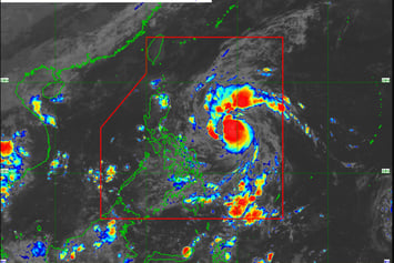
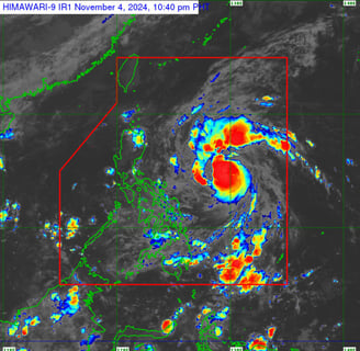
Severe Tropical Storm Marce, locally named Yinxing, is intensifying as it tracks northwestward across the Philippine Sea. Currently positioned 715 km east of Daet, Camarines Norte, Marce carries sustained winds of 100 km/h with gusts up to 125 km/h. Warnings are in place, with Tropical Cyclone Wind Signal No. 1 raised over parts of Northern Luzon, including Batanes, Cagayan, Babuyan Islands, and Isabela, where residents should prepare for strong winds and possible minor disruptions to life and property.
CURRENT EVENT
LTM, Dreamer
11/4/20242 min read
Tropical Cyclone Update No. 4 – Severe Tropical Storm Marce (Yinxing)
Issued at 11:00 PM, November 4, 2024
Next Update at 5:00 AM, November 5, 2024
Overview:
Severe Tropical Storm Marce has intensified as it continues moving northwest.
Key Information:
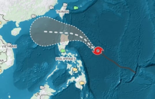
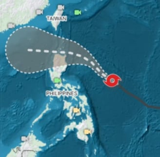
- Current Location (as of 4:00 PM): Approximately 715 km east of Daet, Camarines Norte (14.5°N, 129.6°E).
- Strength: Sustained winds of 100 km/h near the center, gusts reaching 125 km/h, with a central pressure of 985 hPa.
- Movement: Heading northwest at 35 km/h.
- Wind Reach: Strong to storm-force winds extend outward up to 600 km from the center.
Tropical Cyclone Wind Signals (TCWS)
Signal No. 1
Wind Risk: Strong winds (39-61 km/h, Beaufort scale 6-7)
Lead Time: 36 hours
Affected Areas:
- Luzon: Batanes, parts of northern and eastern Cagayan, Babuyan Islands, eastern Isabela, northern Apayao, northern Abra, and northern Ilocos Norte.
Expected Impact: Minor risk to life and property in these areas
Additional Hazards
- Heavy Rainfall: For detailed rainfall predictions, refer to Weather Advisory No. 1.
- Severe Winds: Stronger winds may be felt in coastal and mountainous areas.
- Potential Maximum Signal: As Marce intensifies, TCWS No. 4 could be raised.
Areas Expecting Strong Winds & Gusts
- November 5: Ilocos Sur, Aurora, Quezon, Camarines Norte.
- November 6: Ilocos Region, Quezon, Camarines Norte, Camarines Sur, Catanduanes.
- November 7: Ilocos Region.
Coastal Waters Advisory
Sea Conditions (24-Hour Outlook)
- Rough Seas:
- Up to 3.5 meters: Batanes seaboards.
- Up to 3.0 meters: Seaboards of Babuyan Islands, Ilocos Norte, Ilocos Sur, Isabela, and northern Aurora.
- Moderate Seas:
- Up to 2.5 meters: Seaboards of Cagayan and Aurora, northern and eastern Polillo Islands.
- Up to 2.0 meters: Areas including northern Quezon, Camarines Norte, and parts of Catanduanes, Albay, and Sorsogon.
Mariners and small vessels are advised to avoid navigating in these areas.
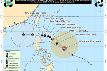
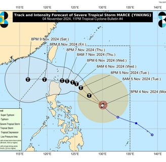
Forecast Track & Intensity
- Movement: Marce is expected to shift west-northwest by November 5, slowing over the Philippine Sea east of Northern Luzon.
- Landfall: Projected to hit the Babuyan Islands or northern Cagayan late Thursday or early Friday.
- Intensity: Marce is likely to strengthen further, potentially reaching typhoon status by Tuesday evening or early Wednesday.
Safety Measures
Residents and local authorities should take precautions and follow advisories. Those in flood, landslide, or storm surge-prone areas should prepare for possible evacuations.
LATEST UPDATES FROM DOST_PAGASA
https://www.facebook.com/PAGASA.DOST.GOV.PH/videos/1040310597778577
Next Update: The next bulletin will be released at 5:00 AM tomorrow.
Photo from zoomearth.com
Insights
Honest reviews for informed shopping decisions.
Quality
Trust
info@reviewph.com
+63-9197557861
Disclaimer: The material used in this is purely for [educational/entertainment/informational/etc.] purposes. We do not claim ownership of the [music/images/footage/etc.] used, and no copyright infringement is intended. All rights go to their respective owners. If you are the [artist/creator/rights holder/etc.] and would like us to remove this content, please contact us and we will comply with your request immediately.
© 2024. All rights reserved.