
Tropical Storm Marce (Yinxing) Enters the Philippines:
Typhoon Marce, also known as Typhoon Yinxing internationally, is a recent tropical cyclone that has affected the Philippines and other parts of Southeast Asia. Named "Marce" by PAGASA, the Philippines' weather bureau, the storm developed as Tropical Storm Yinxing in the western Pacific, impacting the region with heavy rainfall, strong winds, and storm surges.
CURRENT EVENT
LTM, Dreamer
11/3/20242 min read
Tropical Storm Marce (Yinxing) Enters the Philippines:
Issued on November 4, 2024, 5:00 AM (PHT)
As of early this morning, Tropical Storm Marce, known internationally as Yinxing, has intensified from a tropical depression and entered the Philippine Area of Responsibility (PAR). Here’s the latest on Marce’s location, intensity, and expected impact across the Philippines.
Current Location and Intensity
As of 4:00 AM today, Marce was located approximately 935 km east of Eastern Visayas (coordinates: 11.5°N, 134.3°E). With maximum sustained winds of 65 km/h and gusts reaching up to 80 km/h, Marce continues to gain strength, with central pressure recorded at 1002 hPa. Moving west-northwest at 25 km/h, the storm has been extending strong to gale-force winds up to 380 km from its center.
Forecast and Expected Track
Marce is projected to continue on a west-northwest path, with a forecasted slowdown as it moves closer to Northern Luzon. By midweek, it may either take a turn westward towards Luzon or remain erratically east of Northern Luzon. Given this uncertainty, there’s a possibility of landfall in the Babuyan Islands or areas further south in Isabela, though this forecast may change as more data comes in.
By tomorrow, Marce is expected to reach severe tropical storm strength and may even intensify into a typhoon by tomorrow night or Wednesday morning. Rapid intensification is possible, so residents in affected areas should closely monitor updates.
Heavy Rainfall and Wind Forecast
Starting tomorrow, the storm’s movement is expected to enhance the northeast monsoon (or "amihan"), bringing rainfall over Northern Luzon, especially in areas including Cagayan, Isabela, and northern Quezon. Additionally, strong winds are expected, particularly in coastal and mountainous areas. Wind Signal No. 1 may be raised in parts of Cagayan as early as tomorrow, with the potential for Wind Signal No. 4 if Marce continues to intensify.
Areas Expected to Experience Strong Winds and Rain:
- Today (Nov 4): Batanes, Cagayan (including Babuyan Islands), Isabela, Ilocos Norte, Aurora, and parts of northern Quezon.
- Tomorrow (Nov 5): Additional regions including Ilocos Sur and Camarines Norte.
- Tuesday (Nov 6): Wider impact across Ilocos Region, Quezon, and parts of Bicol.
Sea Conditions and Marine Warnings
Mariners, particularly those in small vessels, should be cautious or avoid venturing into the affected seas where wave heights are forecasted to reach up to 3 meters along the seaboards of Batanes and Ilocos Norte. Conditions will be slightly better in other areas but still potentially hazardous, especially along the eastern seaboard of Northern Luzon and Bicol
Safety Precautions and Preparedness
Residents in areas prone to flooding and landslides should stay alert and follow any evacuation instructions from local officials. Prepare for possible power outages and other disruptions, and keep emergency supplies on hand. PAGASA and local authorities will continue to monitor Marce’s progress and provide updated advisories.
The next bulletin is scheduled for 11:00 AM today, with additional information on any significant developments. Stay tuned to PAGASA updates and stay safe as Marce continues its course.
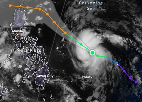
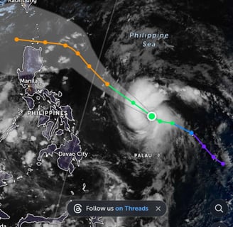
Photo from, Zoomeart.com
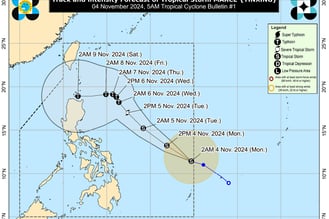
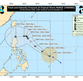
Typhoon track update from DOST_PAGASA
https://www.facebook.com/photo/?fbid=985977093573944&set=pcb.985979640240356
Insights
Honest reviews for informed shopping decisions.
Quality
Trust
info@reviewph.com
+63-9197557861
Disclaimer: The material used in this is purely for [educational/entertainment/informational/etc.] purposes. We do not claim ownership of the [music/images/footage/etc.] used, and no copyright infringement is intended. All rights go to their respective owners. If you are the [artist/creator/rights holder/etc.] and would like us to remove this content, please contact us and we will comply with your request immediately.
© 2024. All rights reserved.